
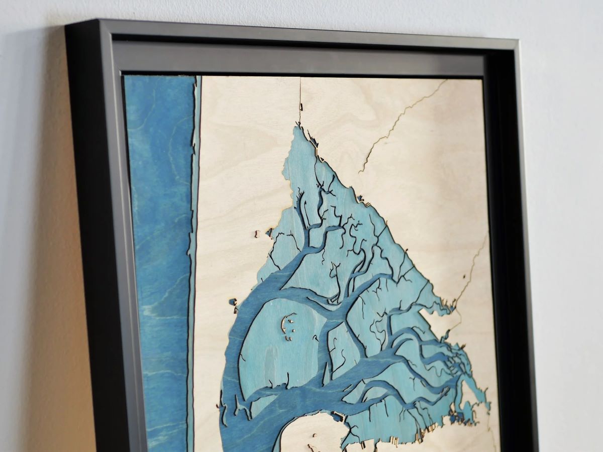
Loving the region from the ground up, we discovered another facet of the Arcachon basin by creating this unique work: its striking resemblance to a lung at low tide.
The dunes, and in particular the famous Pilat dune, give additional relief and dynamism to this topographic map.
Geography and topography of the basin
Located in the heart of the Landes de Gascogne, the Arcachon basin has an easily recognizable triangular shape. It is delimited by the Cap Ferret peninsula to the West, the Gironde plains and forests, the Leyre delta to the South-East, but it is open to the Atlantic Ocean to the South-West, unlike the others. large Landes lakes.

The passes
This opening onto the Bay of Biscay is made by a set of channels, the “passes”, which bring in and out twice a day at the rhythm of the tides impressive volumes of water. The location of the passes is constantly evolving, the markup and nautical charts must be constantly updated for navigation. We used IGN land-sea boundary data from 2020 and we may need to update the wooden map in a few years. For now, we can appreciate the elegance of this unique ecosystem as it is and imagine the daily water movements that occur there. The areas submerged at high tide but uncovered at low tide are represented by a layer of turquoise blue wood which contrasts with the navy blue of the ocean and permanent bodies of water.
The islands
In the center of the basin is Bird Island which is actually a collection of islets (the largest of which are visible on this map) resting on a wild sandbank. There we find the iconic tchanquée cabins (on stilts).
To the South-West at the exit of the pass is the Banc d'Arguin, also appreciated for its photogenic side.
The dunes
The Banc d'Arguin is part of the dune cord which includes the Pilat dune and Cap Ferrêt and partially isolates the basin from the Ocean.
The Pilat dune is an exceptional natural monument. It extends for almost 3 kilometers and culminates at more than 100m, making it the highest dune in Europe. Its significant height allowed us to represent it on this wooden topographical map: its relief is unique and we can easily guess how the wind coming from the Ocean could have shaped it. The face exposed to the West is gentle because the sands spread out upwards while on the forest side the slopes are steeper and irregular. This is also a variable relief that is constantly in motion.
Those who have the courage to climb to the top discover a breathtaking panorama of the ocean, the basin and the pine forest as far as the eye can see. Cap Ferret, its lighthouse and the beaches of the Silver Coast are also visible there.

Photo by Alexandre Rodrigues on Unsplash
Streams
The basin receives water from Lake Cazeaux via the Canal des Landes, from Lake Lacanau via the Canal des Etangs and fresh water from the Leyre which is also at the origin of its formation. Several other streams provide a continuous flow of water. On the map, these watercourses break the topographical monotony of the Landes plains.
Towns
Human constructions are too small to be represented on our wooden topographical maps but with a little imagination and geographic location we find around the basin in a clockwise direction starting from Cap Ferret: Lège, Arès, Andernos-les Bains, Biganos, Gujan-Mestras, la Teste-de-Buch, Arcachon and Pyla-sur-mer.
Technical details of the wooden board
Dimensions
The table measures 50cm high and 40cm wide, it is made up of 5 levels of 0.8mm thick birch sheets, each laser cut with precision. Nearly 10 hours of meticulous, manual work are required to assemble the 150 pieces (some of which are painted with natural pigments) that make up the painting.
Relief
The map is generally to scale (1mm corresponds to 55m of terrain) with a height difference equal to the altitude of the Pilat dune (110m). The height of the turquoise layer representing submerged land at high tide is not to scale, but the depiction of these particular areas with exaggerated relief gives additional depth to the painting. You can touch the relief, the ribs and the slight roughness of the wood and smell its natural and captivating scent.

Decoration
The wooden board comes framed and ready to install with a brass rope which allows it to be easily centered on a single fixing point.
Where to hang your wooden topographical map of the Arcachon basin?
It's as if it was made to decorate the living room or bedroom of a Landes chalet. To illustrate our remarks we took the liberty of using below the photos of ©Christophe Rouffio taken from an article in the magazine Elle ( https://www.elle.fr/Deco/Art-decoration/decoration-maison- in-the-Landes#A-house-in-the-Landes-that-smells-of-holidays4 ).
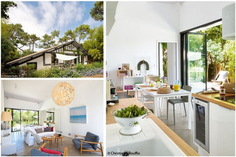
A personalized touch of wood would add a lot of relief to the refined and natural white-wood decoration of this superb half-timbered house.
Find the table and more information on its dedicated page: https://www.boilise.com/products/bassin-arcachon
Leave a comment
All comments are moderated before being published.
This site is protected by hCaptcha and the hCaptcha Privacy Policy and Terms of Service apply.